Great Falls (Potomac River)
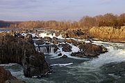
Waterfalls on the Potomac River in Maryland and VirginiaGreat Falls is a series of rapids and waterfalls on the Potomac River in the state of Maryland 14 miles (23 km) upstream from Washington, D.C.. As the border between the states of Maryland and Virginia generally follows the low-water line on the Virginia side, the river and falls at Great Falls lie within Montgomery County, Maryland, which abuts Fairfax County, Virginia on the far shore.
Read article
|File:Great_Falls_Potomac_River_VA.JPG)
|File:Maryland_-_Great_Falls_-_NARA_-_23941085_(cropped).jpg)
|File:Mather_Gorge.jpg)
|File:Great_Falls_Feeder_Dam_(defunct)_at_approx_14.12_mi_for_Chesapeake_and_Ohio_Canal.jpg)
|File:ViewfromOlmstedIslandSouthFootBridge.jpg)
|File:GreatFallsPotomacPanorama.jpg)
|File:Potomac_Great_Falls_panorama_(from_Maryland).jpg)
Top Questions
AI generatedMore questions
Nearby Places

Patowmack Canal
Five canals in Maryland and Virginia, USA
Great Falls Park
National Park Service unit in Virginia, United States

Olmsted Island
Island in the Potomac River, US

Mather Gorge
Gorge of the Potomac River southeast and downriver of Great Falls

Billy Goat Trail
Hiking Trail in Montgomery County, Maryland, US
Bear Island (Maryland)
Island located in Potomac, Montgomery County, Maryland
Matildaville, Virginia
Ghost town in Virginia, United States

Cornwell Farm
Historic house in Virginia, United States